
The Brad Field Weather Podcast
With meteorologist Brad Field and Dan Lovallo


Radar
Possible late day rain
Today, Aug. 2: Mostly cloudy, a rising chance for late day rain; 78 F to 84 F.
Tonight: Rain likely, 1”-2” possible; 66 F to 72 F.
Monday: Rainy; 70s.
Tuesday: Partial clearing, a leftover shower or 2; 78 F to 84 F.
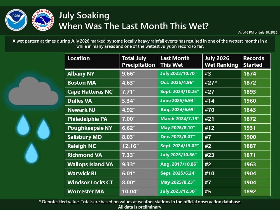
A Wet July
Previous Episodes
- Ice could impact Connecticut commute | Ep. 216
 Ice could impact the weather in portions of Connecticut and New England Mar. 5 into Mar. 6, according to meteorologist Brad Field. In the latest episode of the Brad Field Weather podcast, Field talks about a brief warmup the week of Mar. 8, before winter weather makes another return. A big thank you to the…
 - Connecticut facing winter storm that could be ‘historic’ | Ep. 215
 Connecticut and the northeast are facing a winter storm of “historic” potential, according to meteorologist Brad Field. The storm will strike the region, starting Sunday, Feb. 22 at dusk and last well into Monday, Feb. 23. High winds will also accompany the storm with “Blizzard Warnings” already being posted. Field outlines the storm and its…
 - Connecticut faces stormy weekend | Ep. 214
 Connecticut is in store for a stormy weekend with two winter weather systems impacting the region, according to meteorologist Brad Field. System number one hits on Friday morning, Feb. 20 and lingers through Saturday, Feb. 21. System number two moves in sometime Sunday, Feb. 22 and lasts into Monday, Feb. 23. Weather models are still…
 - Snow and extreme cold and wind on the way | Ep. 213
 Snow and extreme cold is on the way for Connecticut and the region, Feb. 7 into the week of Feb. 8, according to meteorologist Brad Field. Wind chills could reach -40F in some areas as some of the coldest weather in recent memory will make for dangerous conditions. After this weekend’s weather events, the chance…
 - Brutal winter continues. Post Super Bowl storm? | Ep. 212
 Connecticut’s brutal winter continues, although the state should miss a massive coastal storm on Feb. 1, according to meteorologist Brad Field. However, Field predicts the subfreezing temperatures and potential for more snow will continue well into February, including the chance for another major snowstorm around Feb. 10 and 11. As always, a big thank you…
Wind Conditions
